An ArcGIS user wants to create a hierarchy and differentiate cities on a map by categorizing the way the features are labeled.
What should be used to achieve the desired result?
- A . label expressions
- B . label classes
- C . label stacking
- D . label priority
Four emergency response facilities need to be placed so that the greatest number of people in a community can be reached within five minutes.
Which analysis method is used to make this determination?
- A . location allocation
- B . closest facility
- C . route
- D . Dufer
In a disconnected environment a data receiver fails to send acknowledgement messages often enough.
How will the data sender respond?
- A . Resends change messages
- B . sends the next change messages
- C . Slops sending change messages
- D . Discards the change messages
When is an ArcGlS user required to change the format of data before working with it in ArcMap?
- A . when the data is an ESRI interchange (.e00) file
- B . when the data is an Autodesk dwg file
- C . when the data is an ERDAS Imagine (img) file
- D . when the data is in a JPEG (jpg) format
An ArcGIS user is making a map and needs to symbolize cliff and escarpment features above contour features.
How can the features be ordered correctly if they are all in the same layer?
- A . set a definition query
- B . use symbol level drawing
- C . use scale-dependent drawing
- D . reorder the symbols in the symbology properties
After the ground water is the local community was contaminated by a landfill, the health department requested a map showing the cancer rate for each postal code. An ArcGlS user Is provided a file geodatabase feature class (FeatureClassA) that has been joined to a cancer rate table (TableB). The cancer rate table does not have data for each postal code In the study and also contains data outside the study area creating null values. To eliminate the null values from being symbolized.
Which exclusion query should be used?
- A . (FeatureClassA OBJECTED is Not Null) and (TableB.cancerrate Is Not Null)
- B . ("FeatureClassA OBJECTED" is Not Null) and (TableB.cancerrate is Not Null)
- C . ("FeatureClassA OBJECTED". "TableB cancerrate" is Not Null)
- D . ("FeatureClassA OBJECTED" and "TableB cancerrate" is Not Null)
An ArcGIS user processes a point feature class using the Collect Events tool. The user finds that the output value for each feature is 1.
Why did the tool only produce values of 1?
- A . NONE of the points are co-located
- B . mere is only one event to collect
- C . All points are within a standard distance of one other point
- D . The total value of all events adds up to 1
An ArcGIS user wants to make a map displaying the data using an equal number of features in each classification.
Which classification method should the user employ to accomplish this?
- A . equal Interval
- B . natural breaks (Jenks)
- C . quantile
- D . standard deviation
Refer to the exhibit.
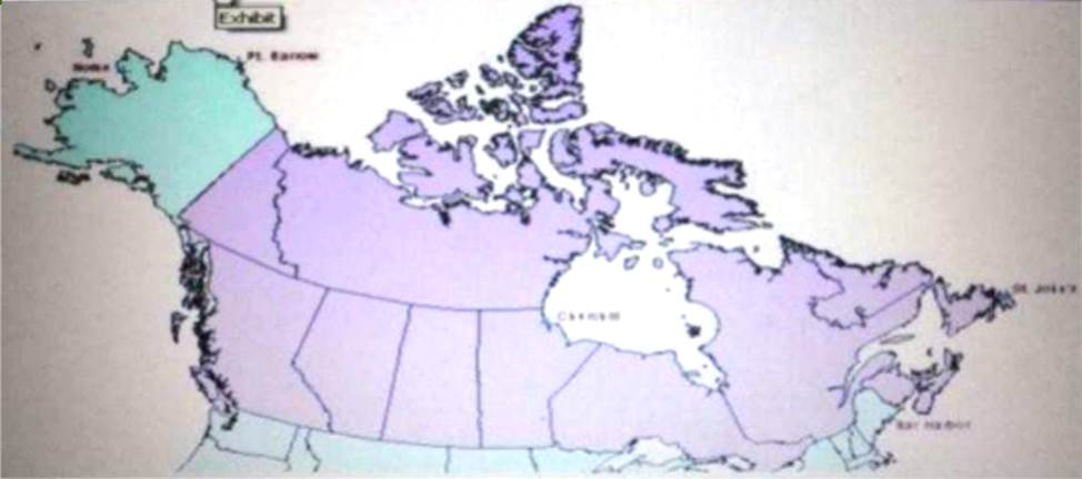

The ArcGIS user is given data for the Arctic, and is asked to perform various types of analysis using the data. The data extends from the North Pole south to 55 degrees North Latitude Data layers may contain points lines, or polygons and include ice surveys from NOAA depth contours; continental margins, locations of known and suspected oil reserves, endangered species habitat and territorial boundaries for nations having Arctic coastline.
An ArcGIS user is asked to calculate the distance a cruise ship will travel through open water, departing from Nome, Alaska, with stops at Point Barrow Alaska Churchill Manitoba St John’s Newfoundland and ending in Bar Harbor Maine. On the basis of these calculations the cruise ship line will determine fuel requirements and travel time.
Which map projection yields the most accurate results for this distance calculation?
- A . Albers equal area conic
- B . Lambert azimuthal
- C . Mercator
- D . azimuthal equidistant
When is an ArcGIS user required to convert a triangulated irregular network (TIN) surface of elevation to a raster?
- A . when generating contours
- B . when extracting slope information
- C . when creating the steepest path
- D . when performing map algebra
A-layer tiding simple symbology is causing slow drawing performance at a scale where analysis needs to be conducted. Only certain features from this layer are necessary in order for analysis to be completed by the ArcGlS user
What can the user do to increase drawing performance?
- A . reproject the layer
- B . run the MXD doctor on the map document
- C . apply a definition query
- D . set a scale range to hide the layer
An ArcGlS user receives two shapefiles that are defined with the same projection and represent features in the same study area. When they are displayed together in ArcMap. the difference of their locations in coordinate space is so large that they are barely visible when viewed at their full extent.
How can the user determine whether the projections of the shapefiles are correctly defined?
- A . by comparing the shapefiles to a correctly projected dataset that has a large enough extent to encompass the study area.
- B . by systematically changing the spatial reference of the data frame until the shapefiles correctly align.
- C . by using the Spatial Adjustment toolbar to move the shapefiles to the same part of coordinate space.
- D . by examining the metadata of both shapefiles to determine the projection processes applied to the data1.
An ArsGIS user has a Python script to synchronize a geodatabase with large numbers of updates from the server.
Why does the ArcGIS user benefit from scheduling the synchronization process through Task Scheduler?
- A . The Windows Task Scheduler runs the script automatically and can be set to run during off peak hours
- B . The Windows Task Scheduler prompts if there are any data validation errors and logs them in a text file
- C . The Windows Task Scheduler prompts if the server is not available and logs server errors in a text file
- D . The Windows Task Scheduler validates the script and opens it in a default debugging environment
In the Feature Class to Feature Class tool which parameter allows an ArcGlS user to manipulate attributes to be included the output feature class table?
- A . input features
- B . SQL expression
- C . configuration Keyword
- D . field mapping
An ArcGlS user has high-resolution single-band data and another raster datasetthat is multiband with lower resolution.
Which process is used to convert the single-band data to multi-band, while retaining its resolution?
- A . stack bands
- B . NDVI
- C . pan sharpen
- D . visualize
For a project, an ArcGlS user creates a custom user interface form to allow data entry and editing directly with the database. This form must be available within ArcMap and also as a stand-alone tool.
How can this custom form be made available within ArcMap?
- A . as a layer package
- B . as a custom transformer
- C . as an add-in
- D . as an ArcPy Python script
Upon opening a model In ModelBuilder. one 01 the tools has a repair icon next to it.
How can the model be repaired?
- A . Select and update the problem tool
- B . validate and save the entire model to update the tool
- C . open the model properties and disable the use of relative path names
- D . click the Auto Layout button to update the tool
An ArcGIS user downloads shapefiles from a Web site. The metadata on the Web site Indicates that the spatial reference the same as that used in the user’s workplace, but the downloads draw southwest of the user’s data and the downloaded data appears too small.
What is the most likely cause of the alignment problem?
- A . The metadata refers to an incorrect datum
- B . The linear units referred to in the metadata are incorrect
- C . The central meridian from the metadata is incorrect
- D . The latitude of origin from the metadata is incorrect
A taster contains pixels with decimal values.
Which method is used to round raster pixel values to the nearest whole number?
- A . use the Round Up tool (Spatial Analyst), then the Round Down tool (Spatial Analyst)
- B . use the Round Down tool (Spatial Analyst), then the Round Up tool (Spatial Analyst)
- C . use the Plus tool (Spatial Analyst) to add 1. then the Minus tool (Spatial Analyst) to subtract 0.5
- D . use the Plus tool (Spatial Analyst) to add 0.5, then the int tool (Spatial Analyst) to
truncate to the nearest integer
An ArcGIS user is tasked with converting an IDRISI vector format file to a geodatabase feature class. The user does not need to change any aspects of the data source in the output feature class.
Which tool should the user employ?
- A . Feature Class to Feature Class
- B . IDRISI to Feature Class
- C . Quick Import
- D . Raster to Geodatabase
The ArcGIS user is given data for the Arctic and is asked to perform various types of analysis using the data. The data extends from the North Pole south to 70 degrees North Latitude Data layers may contain points lines, or polygons, and include ice surveys from NOAA depth contours: continental margins, locations of known and suspected oil reserves, endangered species habitat, and territorial boundaries for nations having Arctic coastline.
Which map projection should be used for the data to allow the most accurate buffering of those areas, in order to comply with the U.S court decision that ships may not approach closer than 20 nautical miles to a seal rookery?
- A . azimuthai equidistant
- B . polar stereographic
- C . gnomonic
- D . Lambert azimuthal
Using the Spatial Analyst IDW (Inverse Distance Weighted) tool an ArcGlS user interpolates a point feature class to a raster. The user notices that some high point values near the edge of the feature class seem to have a dramatic effect on the output.
This occurs even in areas that are far from the high edge values
Which two parameters should the user consider changing in the IDW tool? (Choose two)
- A . z-value field
- B . search radius
- C . power
- D . output cell size
- E . weight
An ArcGIS user is creating a script tool to automate a common workflow.
Which tool property ensures that the tool only recognizes intended feature data sources?
- A . output spatial reference property
- B . data type fitter property
- C . workspace data property
- D . data extent property
When designing a geometric network where should the feature classes be stored?
- A . inside a single feature dataset
- B . outside a feature dataset
- C . inside any feature datasets sharing the same spatial reference
- D . inside a topology
In the value for the latitude of origin in a projection tile is modified, making the value less negative (e.g. from -45 to -28).
Which way does the data move?
- A . north
- B . south
- C . east
- D . west
An analyst has a multi band raster, but needs just one of the bands for a project.
Which geoprocessing tool should be used to extract a single band?
- A . Slice (3D Analyst)
- B . Extract by Attributes (Spatial Analyst)
- C . Composite Bands (Data Management)
- D . Clip (Data Management)
Refer to the exhibit.
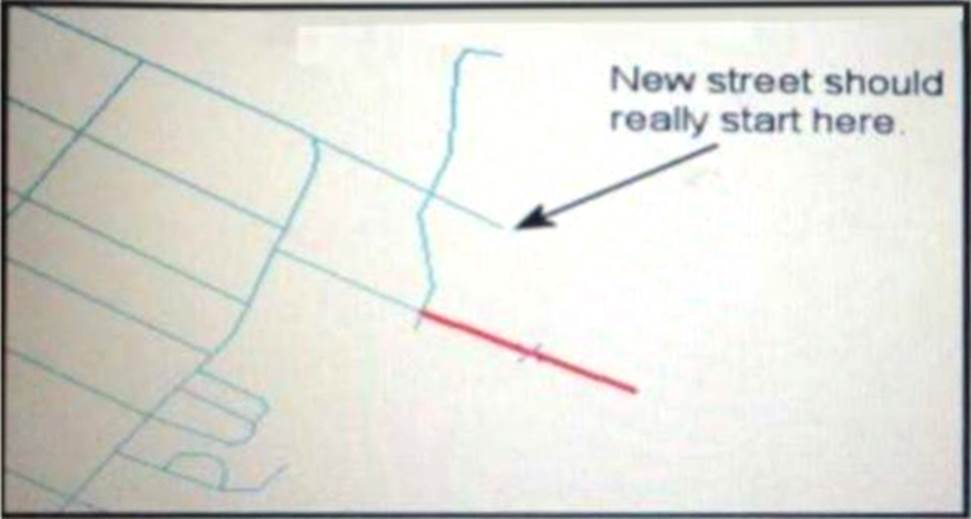

An ArcGIS user added a new street (shown in the exhibit) to a streets feature class within an edit session.
The new street seems to have snapped to an existing street but upon zooming in the ArcGIS user notices that the street is connected to the wrong street.
What is the most likely reason for this error?
- A . The street was digitized at a scale that was too small
- B . The street was digitized at a scale that was too large
- C . The snapping tolerance was set to Low
- D . Edge snapping was turned on Instead of end snapping
An ArcGIS user needs to create a map of flood zones for an insurance company.
The user has a choice of four elevation data sets to perform the analysis
• SRTM 90-meter DEM
• Lidar 5-meter DEM
• 30-meter DEM derived from stereo imagery
Which type of elevation dataset will create the most accurate flood zones?
- A . USGS 30-meter DEM
- B . USGS 30 meter DEM
- C . SRTM 90 meter DEM
- D . Lidar5-meter DEM
- E . 30-meter DEM derived from stereo imagery
An ArcGis user is making a small-scale map using road data that was collected at a large scale.
What is the appropriate tool for removing some of the road detail?
- A . Thin Road Network
- B . Simplify Line
- C . Collapse Dual Lines to Centerline
- D . Smooth Line
An ArcGIS user needs to classify 25 different vegetation types. The user has a single band.
20- meter resolution image with 10-meter spatial accuracy.
Which type of accuracy is the data lacking?
- A . Horizontal
- B . Spectral
- C . Vertical
- D . Spatial